TABLE OF CONTENTS
Basic Spatial Units
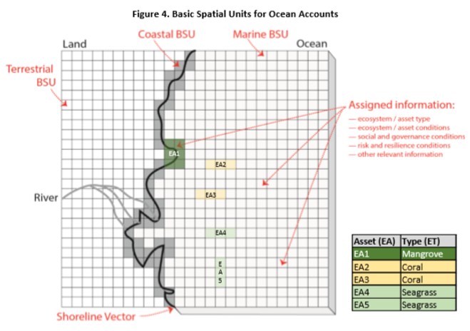
How do we measure and record information about the ocean environment? Basic elements of the spatial data infrastructure in an OAF should include shoreline, bathymetry and the designation of spatial units (i.e., Marine Basic Spatial Units (MBSUs or BSUs for short) based on a grid or other spatial framework). The Basic Spatial Unit may be as small as a remote sensing image pixel (30-100m), a national grid reference system (1nautical mile) or small administrative units (e.g., marine statistical area).


*BSUs have been retained in the SEEA EA but are now regarded to implement the accounting approach rather than being conceptually nested within the process. The SEEA EEA Revision Working Group on spatial units noted that despite the general approach for describing different spatial areas in an accounting context (ecosystem accounting areas (EAA), ecosystem assets (EA) and basic spatial units (BSU)) having become well established, there are still important matters requiring resolution (SEEA EEA Revision Working Group, 2019).
3D Challenges
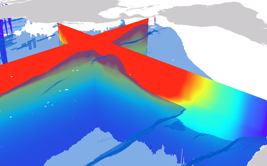
While all spatial accounting processes are complex, it is apparent that fluidity as well as both vertical and horizontal movements within the ocean space result in considerably higher complexity in ocean spatial delineation compared to similar processes in the terrestrial space.Several approaches to capturing this level of complexity are being explored and at least one example is represented in the diagrams below.

A voxel layer represents multidimensional spatial and temporal information in a 3D volumetric visualization, or spacetime cube as depicted above.

X, Y, Z ,T in which each dimension represents geographic coordinates and includes a fourth dimension representing time.

The ecological marine unit voxel layer depicted above shows a cross section of temperature with an isosurface of oxygen saturation (ESRI 2018).
The OAF WP2 Oceanographic research team has endeavored to tackle this complex issue through their work on ODET (the Ocean Data Explorer Tool) and through iterations of creating 3D voxel layers for Algoa Bay. The limitations in using in situ data in this particular area are due to the number of oceanographic stations in the bay. It is reccommended to have at least 60 surface points with accompanying data through the water column and we recreated the layers using only 8 points. This can be resolved by incorporating modeled data in addition to using the in situ station data.